Timelapse of 2023 Fire Season
This video shows a timelapse of the fire heat points detected by GINA over the course of the 2023 Alaska Fire Season from May 15, 2023 to September 5, 2023
Timelapse of 2023 Fire Season Read More »


This video shows a timelapse of the fire heat points detected by GINA over the course of the 2023 Alaska Fire Season from May 15, 2023 to September 5, 2023
Timelapse of 2023 Fire Season Read More »
By Grace Veenstra This article can also be found in UAF’s Aurora magazine in the Fall 2022 issue, and in the IAWF’s Wildfire magazine in the 2023 Q1 issue. Dynamic. That is how Alaska smokejumper Pat Johnson describes wildland fire in Alaska. “It may be relatively calm, a little smokey,” Johnson said. “The fire is
Heat Point Mapping: Using Satellites to Track Wildland Fire Read More »
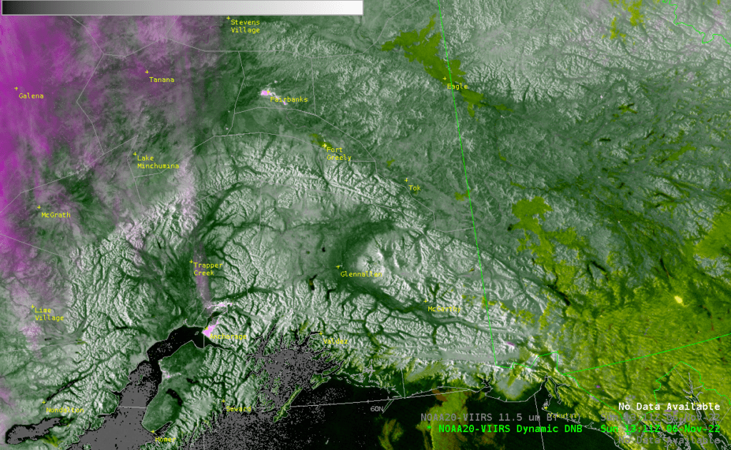
Living this far north means that the Alaskan winters are dark, with very little direct sunlight. This limits the use of some satellite products, such as True Color or the DayLandCloud, which rely on visible light wavelengths to capture images. However, many satellite products can continue to operate even at night, which is invaluable to
Snow, Fog, Clouds and Some Nighttime Views Read More »
GINA collects satellite data around the clock from the satellites that pass over Alaska every day. This graphic shows the number of VIIRS infrared passes received each day by GINA’s Direct Broadcast antennas. The North Slope of Alaska into the Arctic Ocean is the most frequently covered area, with around 16-18 passes per day. Radiating
VIIRS Pass Frequency Read More »
The Tatlawiksuk Fire, 41 miles south of McGrath, has been burning steadily (as of posting) since June 4th, sparked by the recent lightning storms in Southwest Alaska last week. These VIIRS animations of DayLandCloudFire (left) and the i04 band (right) show the change of the fire perimeter (in bright red) from June 8th to June
On Fire Pixel Saturation Read More »
This is the third of a three part series about parallax issues with satellite data. Part 1 was an introduction to the problem and Part 2 focused on specific concerns with regard to geostationary data, but parallax is not only a geostationary satellite problem. In this section we’ll more closely examine parallax considerations with polar
The Problem with Parallax: Part 3 Read More »
This is the second of a three part series about parallax problems with satellite data. Part 1 presented an overview of parallax in this context and reviewed differences in orbital characteristics of geostationary and polar satellites. In this section we’ll examine more closely parallax issues associated with geostationary satellites. Part 3 will cover the topic
The Problem with Parallax: Part 2 Read More »
What is Parallax? Parallax is the apparent difference in the location of an object based on point of view. With satellite data this is always something important to consider, because the features you see may not actually be where they appear. This is the first of a three part series focused on the parallax problem.
The Problem with Parallax: Part 1 Read More »
The fire imagery can be a little deceiving sometimes. As seen in these images, something that appears like smoke is streaming from the peak of Denali. Not to worry, it didn’t suddenly become a volcano, instead it’s due to a little trick of the clouds. VIIRS i04 band (3.74 um), 21:00 UTC 01 June 2022
Mountain Smoke Plume, Or Is It? Read More »
Interesting cloud formation on the Alaska’s North Slope 08 Feb 2022. This streaking appearance of clouds is often caused by a moist layer and mechanical lift generated by terrain, but this is pretty flat territory…
Unusual Cloud Streaks from Oil Flares Read More »